Wind River high

There are several controversies which must be dispensed with before discussing a high backpacking route through the Wind River range.  The first is integrity.  A few years ago Alan Dixon and Don Wilson released a detailed, free, online guide to a route they hyped as “better than the Sierra High Route.”  If online reports are any indication, this line has proven very popular.  This past summer Andrew Skurka completed a different line, which is longer in miles, hews more closely to the Continental Divide, and traverses the heart of the high Wind Rivers end to end.  Ryan Jordan, CEO of my sometimes-employer BackpackingLight (of which Dixon was a co-founder and former partner), threw fuel on the fire back in November by titling a blurb on Skurka’s achievement “Andrew Skurka completes authentic Wind River High Route,” though authentic has since been deleted from the title.  Skurka, in the course of discussing his route and in the guidebook he recently released (and which I will discuss below), has made no bones that he considers his version a higher quality and more rigorous iteration of the concept, albeit one with more physical and logistical challenge.  As of this writing I’ve only been in the Winds once, on a climbing trip to the Cirque of Towers many moons ago, so my commentary on this question will of necessity not be extensive.

The second controversy concerns the nature, and ethics, of guides to such routes.  In my own Crown of the Continent Packrafting guide I wrote “My hope is to provide enough information for someone utterly unfamiliar with the area, and visiting for the first time, to put together a high-quality trip, while at the same time maintaining a healthy level of ambiguity and thus, adventure.”  I’m a believer in the virtues of the online, information economy (I wouldn’t be writing here otherwise), but I do think the dissemination of information can be abused.  To be blunt, Dixon and Wilson are a prime example of how not to publish backcountry beta: their guides are extremely detailed in all respects, for accessible objectives in accessible locales, and they are free.  Combining two of these is treading dangerous water, combining all three is a proven recipe for significant increased traffic in a very short period of time, be the objective in question backpacking, climbing, mountain biking, paddling or fishing.  Creating barriers to entry that require effort to solve, but are solvable by anyone given enough time and effort, is a proven way to diffuse traffic from high profile and potentially high risk areas (both ecologically and technically).  So how does the beta version of Skurka’s Wind River High Route measure up to this standard?

Screen Shot 2016-02-13 at 10.16.10 AM

Andrew contacted me last summer to look at a pre-release version of his Kings Canyon High Basin route, which was useful for both of us; he got feedback from a completed fresh and unstudied eye, and I got to read about and look at cool maps for a place I’ve never been.  I similarly got to look at the beta version of his Wind River High route guide.

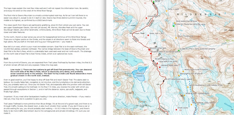
As you’d expect from a backpacker whose haulmark has been eliminating logistical and planning snags from complex, new, multi-month routes, Skurka’s guide is both complete and brief.  Maps, map annotations, mileage charts, and the written descriptions which contextualize all of the above are intuitive and to-the-point.  I particularly like his style of map marking, which places points at relevant locations without drawing a line in between (which the Dixon/Wilson mapset does).  It’s a small thing , but the net effect is that buyers can choose the level of detail they bring with them into the field.  The maps have just enough route information, and just enough annotation about things like stream crossings, water sources, and camps, that in the field they would be quite adequate on their own.  A big part of all my off-trail traverses has always been the satisfaction found in micro and meso route finding, and Skurka preserves that as well as he can in a guide which strives to provide as much detail as he does.  For those wanting detail, his website and the for-sale guide together answer every question, for logistics to time of year to equipment, one might possibly have.

Otherwise there isn’t all that much to say.  I feel bad for giving more space to bloviation than reporting, but Skurka provides a good route and a guide to it which doesn’t really leave any questions dangling, besides when I might have the time to go hike it.  One cannot reasonably ask for more.

7 responses to “Wind River high”

  1. I’m going to quote a friends comments, but my basic sentiment is the same: why does he have to turn the entire range into a single goal? What is Skurka getting at here? Hiking off trail in the winds is obvious, he isn’t a pioneer.

    “My disappointment stems from Skurka turning this into a “thing”, a trophy, “among the most premier backpacking trips in the world.” Since he is claiming authorship of the route, apparently 8 years in the making, and declaring any variation inferior, he’s turning the Winds (as so many have before) into another tick for the lists of destination warriors that want to lay claim to the best of the best. It’s summarized perfectly by the first comment below his post: ‘I really like the idea of these “short is the new long” backpacking routes that explore the absolute best-of-the-best backcountry in a timeframe manageable for those of us who work for a living.’ This digging implication that the remote wilds are only now being rightfully returned to the loyal sons of capitalism makes me crazy. Anyway, why is it so hard for people to do their own thing and be happy with it? The value of exploring for oneself, and practicing acceptance, has been supplanted by claims to “definitiveness,” claims that are no compliment to the scale and depth of actual mountain ranges; this “Wind River High Route” is not an important discovery. It is a claim to serve the ego of one man. And lastly, why the emphasis on speed? Was it really more interesting for him to “yo-yo” the range, do it two times at double-speed, than once, slower? And then the discussion devolves into gear comparisons, speed records. Maybe that’s what you mean by doofus.”

    1. First things first. Dave, thanks for looking over the Guide.

      Hi, Will. Thanks for sharing your thoughts. I’d like to address some of them.

      1. To pretend like I don’t stand on the shoulders of giants — in the Winds or elsewhere — would be ignorant and small. If you looked around more instead of relying on your preconceived notions of me, you’d struggle to find any claim about being a pioneer in the Winds or in the niche of high routes. Heck, I created a “History” page about the Wind River High Route in order to give credit to the individuals who deserve it, http://andrewskurka.com/adventures/wind-river-high-route/history.

      2. If you have the desire to “do [your] own thing and be happy with it,” and if you have the time to research all of the options, that’s great for you, and I’d encourage you to carry on. But the suggestion that others who lack the time or context — due to competing demands like families and careers, or due to backpacking not being their highest priority — should be deprived of a best-of experience reeks of elitism. Does it adversely affect you if they seek to maximize the potential of their annual big-trip-of-the-year by using second-hand information (provided by me, Dave, Backpacker, WhiteBlaze, etc.) or even by hiring a guide with first-hand expertise? No, it does not, so you should let it be.

      3. Really, more criticism of my hiking speed? Didn’t we close this argument about a decade ago? I don’t tell you how to experience the outdoors, or even make suggestions about it. Please extend that courtesy to me. I am unapologetic about my approach to backpacking, and I am forthright in explaining that I like pushing myself physically and mentally when I’m out there — that’s part of the value for me. But don’t interpret that to mean it’s the sole value. If it were just about going fast, I’d be a full-time runner, not a backpacker that runs.

      In the particular case of my Winds trip, it was part of my training for a 100-mile trail race in September, Run Rabbit Run 100 in Steamboat. I placed third. And the reason that I yo-yo’d the range was because (1) my car was back at Bruce Bridge and I’d rather spend four days hiking instead of one day hitchhiking and (2) it gave me a chance to explore some parts of the range to which I’ve never been, like Bonney Pass and the Lizard Trail. Why complete a single traverse of the range slowly when I can see twice as much terrain in the same period of time? And please don’t give me that cliche about not “stopping to smell the roses.” It’s hard to miss much when you’re walking at 2-3 mph.

      Andrew

      1. Andrew, I couldn’t agree more with your second point. I have time for a single two week major backpack each summer and I use every piece of beta I can find to plan my trips. We just bought your SEKI High Basins guide with the goal of section hiking a portion of the route. I’ve used it to zero in on the Gardiner Basin, but after getting introduced to the area with your guide, I used a ton of other web resources and Google Earth to really examine the area. We’ve decided to modify the route and detour through the 60 Lakes basin instead of crossing King Col, because the 60 – Lakes area looks like better terrain than the drainage north of King Col, and we avoid that nasty crossing and the fording of Woods Creek. My point is that I use every resource at hand to plan and execute a successful backcountry trip, and appreciate having those resources. I’d never have the time do do the exploration on the ground on my own.

        And like Will, I find your maps give just enough beta, leaving plenty of opportunity to choose my own path. As to hiking speed, to each their own. At 67, I’m just glad to manage my 5 – 10 miles a day with strength left at day’s end to pitch the tarp.

        1. Glad that the Kings Canyon High Basin Route Guide has proven useful to you. Good call on the route. King Col is tough, and the Woods Creek ford will be difficult through June and into July after after a wet winter. You’ll be really happy with upper Gardiner Basin and Sixty Lakes — it’s good country; unfortunately for a thru-hiker it’s really out of the way. The only downside is that you will miss Col Creek, which is one of the coolest on the entire High Basin Route — it’s a continuous 2,500 vertical foot granite slab.

          It sounds like you have your route dialed, but if you need some help please ping me. Oh, and keep rocking on — one of my most inspiring clients, with whom I did most of Loop 1 in a week, was 72.

    2. How many times must the phrase “hike your own hike” be typed into the comments section of a blog? If hiking your own hike means saving time planning by accessing available resources from very competent individuals who visited prior then so be it. Mr. Skurka is about as down-to-earth, rationale, and thoughtful as they come when considering his near-celebrity status and I’d say your and your friend’s replies sound like they have a heaping helping of jealousy behind them. Perhaps you need to live and let live and go hike your own hikes? Just my $0.02.

  2. While I don’t entirely disagree, I think definitive can be read rather more charitably as “admitting the finitude of human existence, if I’ll only visit the Winds once, where should I hike?” Everyone will have different answers there, but for me Andy’s maps make a persuasive argument that his route is darn close to my answer to that question.

    It’d be nice to have discussions of relative merits without whitewashing all the contextualizing background.

    1. Very true and good point.

      I shouldn’t of quoted all of my friends comments (discussing hiking speed or ‘hike your own hike’ are some of the least interesting topics to me involving backcountry travel, and anyway I like to hike long days as well..)

      I guess the only point I was really trying to bring up is Skurka championing his completing of the supposed ultimate route in the winds and it being “THE” wind river high route and whatever the implications/attitude behind that is – which seems like your first point and your response was a good one.

      My friends emotions likely stem from being a wilderness ranger in the winds for multiple years and cringing at the online publishing of corridors to some remote and seldom visited areas which he knows well. This is your second point and the only thing that really matters in this discussion. In that case bringing up the fact that Dixon/Wilson are a poor example of how to publish this sort of information might be true, but the claim that charging a small price is a decent barrier to increased traffic, especially to Skurka’s “short is the new long”, “valuable time” audience seems unlikely. Also, his maps and route information seem brimming with enough information that claiming them sparse at all also seems odd – why draw a line with that many points?

Leave a comment