
As opposed to the Little Blackfoot, whose headwaters are too small and brushy for good floating, the Big Blackfoot River rarely runs parallel to a road, something that makes for convenient and high quality floating. The middle section of the Big Blackfoot and its tributaries, which is to say the bit in the Helmville/Ovando valley, downstream from the Highway 141 bridge and upstream of Russell Gates campground, are especially fruitful in this regard, as the loops and bends in the rivers combine with relatively quiet dirt roads to allow for pleasant self-shuttling via bike. Packrafts are the obvious compliment here, but other craft can be floated with the same approach.
Access is somewhat tricky in this valley, due to the large amount of private land and moderate amount of quintessentially American property paranoia. Access sites, highlighted below and listed north to south, are as follows:
-Scotty Brown bridge on River Junction road, which has very limited parking.
-River Junction campground, which has lots of parking but is a longish drive.
-Harry Morgan campground, 2 miles upstream from River Junction on the N Fork of the Blackfoot.
-Raymond road.
-Aunt Molly Wildlife Management Area.
-Cedar Meadows fishing access site.
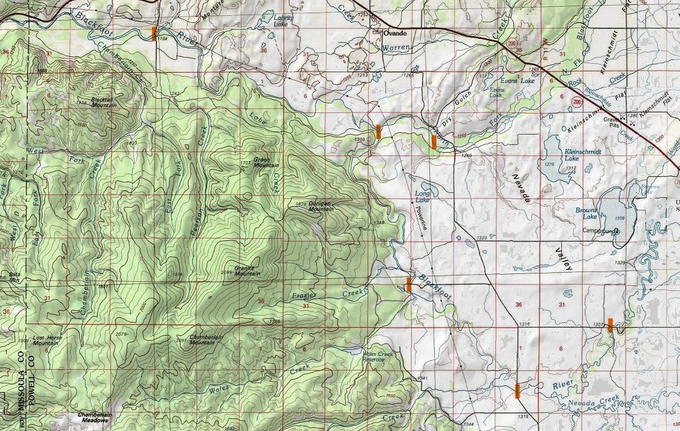
A favorite beginner, kid friendly bikeraft loop is Cedar Meadows to Aunt Molly. This involves 3 miles of riding on dirt roads, and 7 miles of twisty flatwater through brushy islands and farmlands. Not scenic in the traditional sense, but very quiet and with tons of wildlife. Raymond road to either Cedar Meadows or Aunt Molly would extend the day nicely, but the 6 miles from Cedar to Raymond are more agricultural, and open to wind. A canoe is a logical craft on this stretch of the Blackfoot.
The river from Raymond to River Junction is quite pretty, packed with easy class II, and due to access concerns gets little traffic. Crafting a bikeraft loop on this stretch is logistically complicated, at least if you prefer to avoid the highway between River Junction road and Ovando. My late summer solution has been to start biking at Harry Morgan, and end the trip by traveling upriver from the junction of the main and north forks. The north fork is swift enough that you won’t be paddling upriver much, but the gravel bars are extensive enough that walking and/or dragging is not too bad, if a bit tedious. count on 10 crossings in 2 miles, and on having to wade a good bit. Harry Morgan-Raymond-River Junction is well balanced; 6 miles of biking (which a decently skilled rider with tough tires could do on a road bike), 6 miles of floating, 2 miles of upstreaming. In a similar vein, one could float down to Scotty Brown, bike back up to River Junction, and then cross and go upstream. This bit of road is tedious to drive, but good fun on a bike. River Junction road historically went through to the Raymond road bridge, but the Mannix Ranch closed that a number of years ago, with Powell County having taken a 1/2 mile stretch off their list of official county roads. (eyeroll)

Bikes can also be put to good use on the valley stretches of Monture Creek and the middle North Fork of the Blackfoot. I had never run the bit from the later down from FS 5550 (aka the Cooper-Blackfoot road) until the Bob Open this year, and found the first ten miles down to the Dry Gulch road to be an absolute ripper at 900 cfs and above. At 1500 it is almost continuous class III until the final few miles, with a 10 mph current. I’ve yet to float it at low flows, though below 500 I reckon I would actually not mind having my bike on board, as opposed to leaving it in the bushes to drive up and get later. It is possible to ride up on public land through the west bank, but there are a few private land complications and northern stretch gets very brushy following old logging roads.
Below Dry Gulch road the North Fork mellows hugely, with moderate log/brush concerns, and is a class I float all the way to the confluence. A packraft or lightly loaded canoe could get down it, slowly, just about any time, but big boats will stay away below 400 cfs. Some determined oar rigs line down from Harry Morgan at very low flows, due to the ease of access relative to other options. Little Bear and I watched two SUPers go down this past weekend (at 170 cfs), and they and their fins looked to be having a nervous go of it.
Up in the Wilderness Monture Creek used to be a premier creeking run, and is now full of wood from recent fires. This wood hasn’t made much progress downstream, and the stretch from the campground down to either highway 200 or the main Blackfoot is fairly straightforward. I haven’t floated this one at lower water either, and imagine it would get painfully slow much past June.
Why am I detailing all this, especially the delights of the Raymond to Junction stretch? First, because I think tastes and convenience will pose little risk of crowding. Second, to spread some folks out at least a little bit. Third, to establish a bit more use history in relevant spots. Life is easy back in the wilderness without private land issues. The more civilized bits of Montana risk going in a very problematic direction over the near future, as population growth, baby boom cash, and increased paranoia/zenophobia all combine make society more closed to strangers and the public. So get out there, close gates, wave at folks, and be patient with the ATVs moving cows down the Helmville-Ovando road.

Leave a comment