This is both a blog post and an open letter to my fellows in this adventure, as I work out my enormous excitement and figure out my approaches to this undertaking.
Yesterday, in the late afternoon, I was perusing Backpackinglight during a quiet moment at work and came across Le Parcour de Wild. Brilliant. I immediately typed out a resume and emailed it off. When I arrived home less than two hours later, I had two emails waiting, both from the infamous Ryan Jordan. The first informing the field I would be joining them, the second disclosing the route.
Instant gratification, one of my favorite things. Aside from a bit of training, all I did last night was dive right into route research.
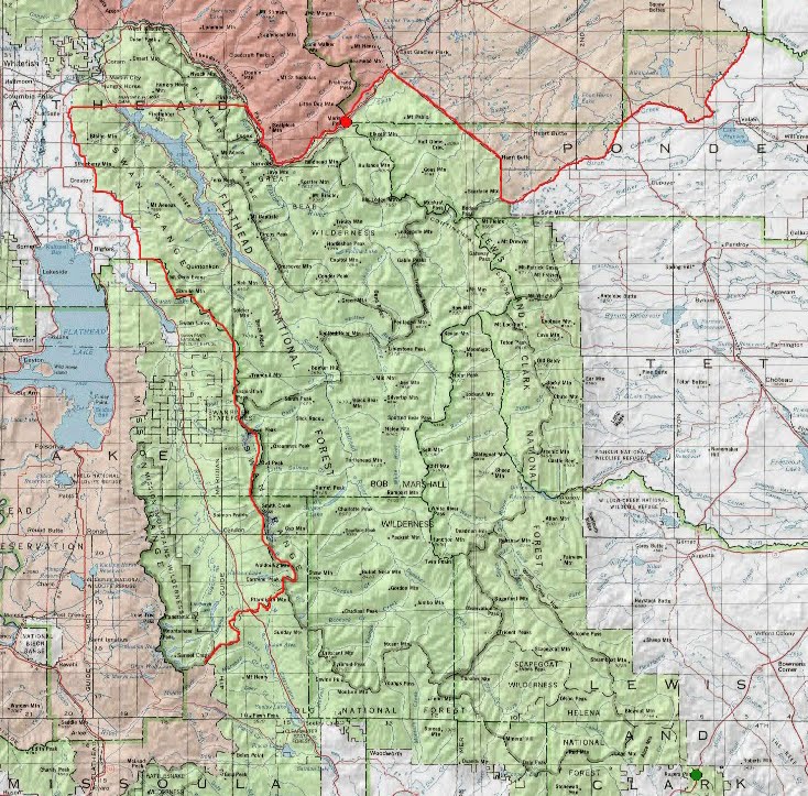
The route travels from Roger’s Pass on Highway 200 in the south, to Marias Pass on Highway 2 up north. Between the two points, the Bob Marshall complex. Rules limit travel in the surrounding non-federal lands. It’s one of the most obvious places in the lower 48 for a AMWCesque “race”. (We need a spring version on the Colorado Plateau.) The rules are standard: human powered travel only, no dropping or caching gear.
Based on my research thus far, the route that would win is obvious. It’s all mountain bike, and would follow a maze of dirt roads from east of route 200 north all the way to the Swift Creek reservoir, then on trails in the Lewis and Clark National Forest (N Fork Birch Creek, Badger Creek, S Fork Two Medicine River, all of which are legal for bikes) right to the finish. Unless the dirt roads are ridiculously convoluted, and/or the trails are really nasty, this route would go in less than 48 hours. Caveat emptor, I haven’t seen any of this on the ground level.
This route also seems somewhat lame. I don’t want to do this just to spend over a day riding gravel and two tracks. So I’m not going that way.
The route I’d really like to do would involve a bike and a packraft. You’d take 200 west to Lincoln, ride the Great Divide Route north and west to the Monture Creek ranger station, then ride up road and trail north to Youngs Pass. At the pass you enter wilderness, strap the bike to the pack and hike down to Youngs Creek, blow up the raft when possible, float all the way down to the Meadow Creek gorge, carry down to the Hungry Horse road, ride the east side road to Trail 62, carry up and over to and then down Sheep Creek, then ride 2 up to the finish. The problem here is that I do not have an Alpacka, but even moreso that average flows for the South Fork of the Flathead for early October are a little below 600 cfs. This route would work only if the floating is expedient, not only on the Flathead but on Youngs Creek as well. It’s not clear to me that this would be the case, and in fact it seems rather unlikely.
So, that leaves two options, both entirely foot based. If there’s not too much snow, following the CDT would be very fun and scenic. Snow could make this not so much fun, so a lower route using either the eastern front on the divide or the South Fork Flathead would likely be called for. In either case, a nice 5-6 day backpacks worth of 30+ mile days is likely in order.
I have almost all the gear I’d want, I just need to scoot over to REI in a bit and buy some maps.
Autumn got a lot more exciting yesterday.

Leave a reply to Roman Dial Cancel reply