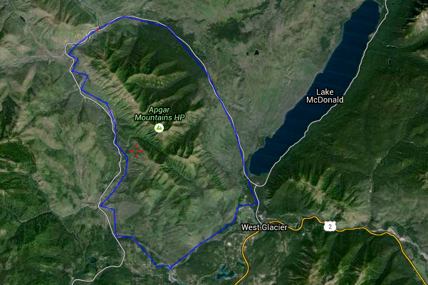
If you’re in the Glacier area with a bike and packraft, and have a hot day to dispense with, this loop is a good way to do it. Something around 35 miles and in the 5-8 hour range depending on the river level and how fast you ride, it has good scenery, convenient logistics, and consistently fast riding terrain and the river will both keep you cool.
 After riding up the Camas Road in the park (paved, climbs steadily for most of the way, light traffic) cross the bridge over the North Fork of the Flathead, walk down to the gravel bar, and do the obligatory bikerafting gear explosion. The North Fork between this bridge and the confluence has a few rapids which are no joke at higher levels, as well as some pretty broad and slow stretches, so picking the right flow is tricky. Between 3000 and 5000 cfs is my suggestion; any bigger and the rapids get hairy with a bike on board (and portaging would be tiresome due to short cliffs), any smaller (like the 2700 I had recently) and the beginning and ending stretches are slow.
I’d also recommend getting a not too late start. The North Fork usually generates fairly stiff upriver winds starting around 1600, which can make the few miles before the confluence frustrating.
The confluence of the North and Middle Forks is easy to spot, as it is right upstream of Blankenship bridge, the first bridge you’ll have seen since the put in. Take out on the small gravel bar at river left right at the confluence and put your bike back together. The old Flathead ranger station road, in Glacier, is atop the hill above the confluence, and is the only real dirt trail in the park open to bikes. It’s a short but steep push on a fisherman’s trail up the hill, and a mostly fast ride back to the trailhead, dirt road, Quarter-Circle bridge over McDonald Creek, and the bike path back to Apgar.
This trail is gentle enough to do on a ‘cross bike. I you have a road bike, take out at Blankenship and ride east (well graded gravel) back to highway 2 a few miles east of West Glacier. A longer and more properly mountain bike version of this would be to ride the inside North Fork road from Fish Creek campground north to a mile or so past Logging Creek, where the river can be accessed via a very short bushwack. This route is on the long end of what is possible for a day trip, and would make a fine overnighter. The NPS boundary is the middle of the river, so as long as you camp on the west bank (and not in someones yard) you are legal.
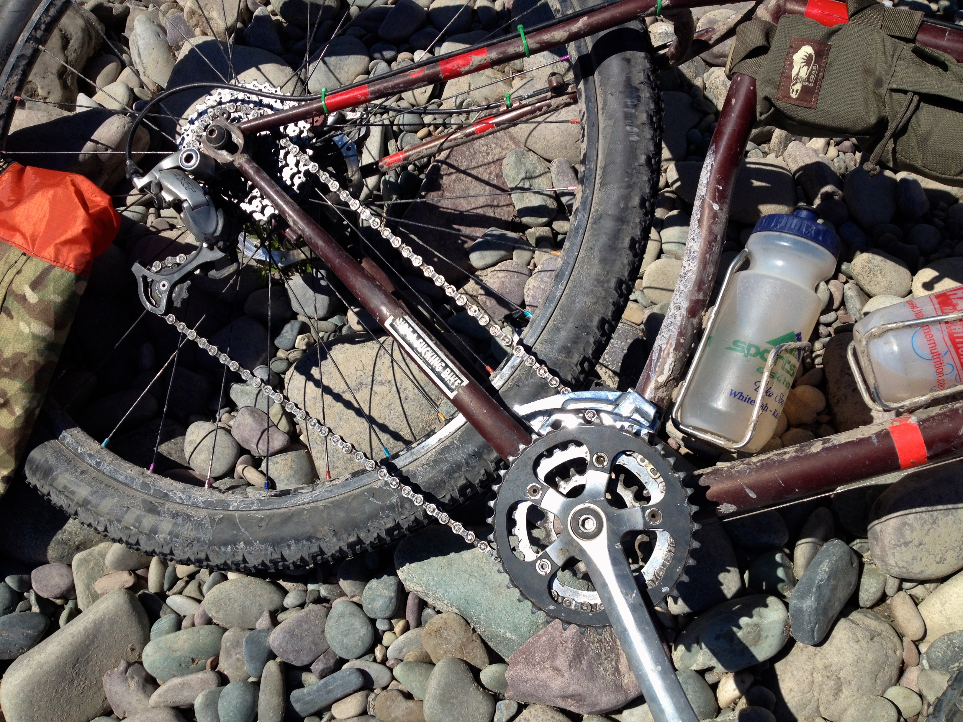 In the name of practicality (Chariot towing) I recently put gears back on the Karate Monkey. Up front are the same Sugino cranks and 20/30/38 chainrings I’ve had for years. The 20 is a steel Race Face, 30 a steel Surly, and both have massive miles with no visible wear. My back wheel is the same Mike C-built Arch on Hope SS I’ve ridden for seven years. It suffered it’s first casualty on this recent trip; I nipple which broke off inside the rim. Considering the miles I’d call that a good record. I used to be able to fit 7 gears, barely, but six is more conservative and the only option now that the edge of the freewheel splines wore a hair. Using cogs from various low end cassettes I have a 14-34 spread, though the jumps wouldn’t make the cadence-sensitive happy. Shifting happens via an X9 twistie for the front, and a Durace/Paul friction thumbie for the rear. XT derailleurs both.

Leave a comment