(update January 2024)
Tenderfoot Creek is the largest west-running drainage in the Little Belt mountains. Like the mountains themselves, it is a unique and somewhat obscure place. It has a public lands story which is worth reading about. As detailed last week, I’ve been mulling this post for a while. I discovered (for myself) floating the creek in the best way possible; looking at a map and then going and doing it. I’ve been back a few times since, and the trips have always been stellar. The Smith River, into which Tenderfoot flows, has long been exceedingly popular, as an easy, scenic, remote-ish, road accessed float. The Tenderfoot is far from popular at the moment, though as a fishing and hunting destination it is coming that way. As a floating destination the time to establish a public use history has arrived.
Tenderfoot itself can be easily split into three distinct sections with significantly different characters. Upstream from the ranch bridge at the outlet of the South Fork of Tenderfoot Creek, to at least a few miles above Rugby Creek the creek is zippy and busy (~100 ft/mile of drop), with continuous class II++ action, a few III+/IV rapids that come up fast, lots of wood in a few spots (more as you get higher), and typical for small steepish creeks, complex and fast decision making. It is an absolutely classic packraft run, and a place for solid whitewater paddlers who also have extensive experience in scappy backcountry runs with lots of hazard and few eddys. The half mile below the bridge (shown on map) drops into an unexpected, shallow, and very steep gorge, with a series of scenic rapids culminating in the 12 foot Tenderfoot Falls. This gorge (250 ft/mile) often has vertical cliffs coming out of the water on both sides with the creek 10-15 feet across, and very few places to scout or portage. Wood is a very real concern here. It is often, but not always, possible to climb out on either side.
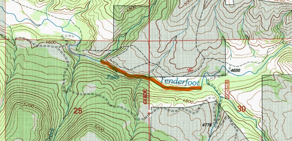
One bend below the falls is the best/only public road access to the creek, and the meandering ~10 miles down to the Smith are far mellower in gradient (40 ft/mile) and hazard. There are riffles, and as with any smallish backcountry stream wood and brush to worry about, but the Tenderfoot seems far cleaner than most in the genre. Backcountry packrafting is inherently not beginner boating, but the lower Tenderfoot is ideal basic intermediate terrain. This lowest stretch is significantly less constricted than the top bits, and even at good flows running out of water is a consistent concern.
Access and creating routes and loops in the area is not simple. Road access from the south, down the South Fork of Tenderfoot, is a good if not short drive from the pavement, and this road can be driven in a passenger car when dry, and if piloted with skill. That said, folks have been rather surprised to see our Saturn down there. Hike in access and route possibilities from Monument Ridge to the north is excellent for the packrafter, and I find the drive in along Logging Creek to be the more enjoyable. Consult the forest service travel maps for current ideas of which trails are maintained. The largest obstacle to coherent routes is that floating on the Smith requires a permit, and furthermore, the final ~mile of the creek passes through private land (owned by the Wilkes Bros, in fact). Montana stream access law permits wading upstream within the ordinary high water bounds, which for this lowest stretch is doable if not so simple, as cliffs force multiple crossings of the creek. At low flows floating this stretch is slower than walking. The trail which parallels Tenderfoot is a mixed bag and not always the easiest to follow.
Loop trips hiking into Tenderfoot from the north and floating down to the Smith are outstanding, with great floating and equally great walking. Some of the trails are well used, some are very not. Finding certain trail junctions is not easy. If you are on a regular Smith float when levels are up, bringing a packraft and spending a day doing such a trip is an excellent idea. Catching up with your party is certainly realistic here, as would be having a layover camp at one of the spots in the ~15 miles downstream from Tenderfoot, especially Sunset, Bear Gulch, or Fraunhoffer, where one can start hiking (or biking!) right from camp.
The season for floating the Tenderfoot has been hard to pin down. May, and most if not all of June, seem to be a sure bet. I imagine April, in early years, and early July, in late melt years, are often workable. The Smith has several gauges, which can be significantly impacted by irrigation draw offs. Additionally, the conditions under which Tenderfoot and Sheep Creeks peak relative to the Castle Mountains and eastern Big Belts seems quite distinct, further complicating trends. As mentioned above, you could have plenty of water for the upper bits and find the lower part quite bumpy.
It is a special place. Be careful.

Leave a comment