As most everyone knows, the mountains of the lower 48 have over the past month produced a fire season which will be discussed for decades. However outstanding, this cannot be a surprise. The mountains of Washington, Idaho, and Montana all had a fairly to egregiously mild winter, and without fail an early spring and a very hot, long summer. Here in the Crown of the Continent Ecosystem, May happened in early April and August happened in late June. The three forks of the Flathead, which drain almost all of the Crown Ecosystem west of the continental divide, have been setting all-time low flows since mid-July.
Most significantly, in the 105 years the last legendary fire season around here, humans have done just about all that we can to eliminate landscape-scale forest fires. There’s a lot more to discuss than I can get to now, but it needs to be said that the month just past, and more like it, ought to be viewed as nothing more or less than a logical consequence of this repression. And we should expect more of the same until accounts are put back to rights.
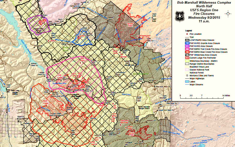 Maps via InciWeb.
The number of fires in the northern half of the Bob has been particularly noteworthy. The Sheep Creek fire, which threatened the community of Essex and closed Highway 2 a few times, got a lot of press, but for backcountry folks the Trail and Bear Creek fires are the most significant. They’ll have the longest term effects, and had the broadest impact.
 These two fires share something will all the major fires on the first map, a start and primary growth in thick, dark pine forest. Both of these larger fires, especially Bear Creek, generated enough momentum to subsequently burn through some recent previous burns, and up into sub-alpine terrain.
 The deeper red patches on the eastern margins of the Bear Creek fire are especially noteworthy. The fire ran all the way up Mid Creek, which was mostly burnt up within the last decade, and spotted through sub-alpine fir into little patches in the head of Silvertip Creek. It was eventually stopped by cooler weather and terrain like that pictured below.
 What will these fires mean for backpackers, packrafters, skiers, and hunters? Short term early rifle season in the Bob may be complicated for many, though the Forest Service will no doubt work to get as many roads and trails open as possible. Rain and snow this weekend should help quite a bit. My 1,2, and 3 options for a hunting trip in a few weeks were all affected by closures, but I’m optimistic that in 12 days I’ll be able to go where I had originally planned.
Longer term a few major trails, like the one along Meadow Creek gorge between the airstrip and Black Bear Creek, will be a lot more open (read: hot). Big game distribution may be pushed around a bit, as what were burns this summer become great areas for feed next fall. Most significant might be the impacts of the Bear Creek and Moose Creek fires on packrafters. Fires, especially hot fires in dense forest, tend to put more wood into rivers in the first few years after they burn, and sections like Black Bear down through Meadow Creek have the potential, with plenty of narrow rock sections, to hold some large and nasty logjams. Certainly something to keep in mind if you end up floating a potentially affected stretch in spring or early summer next year.

Leave a comment